
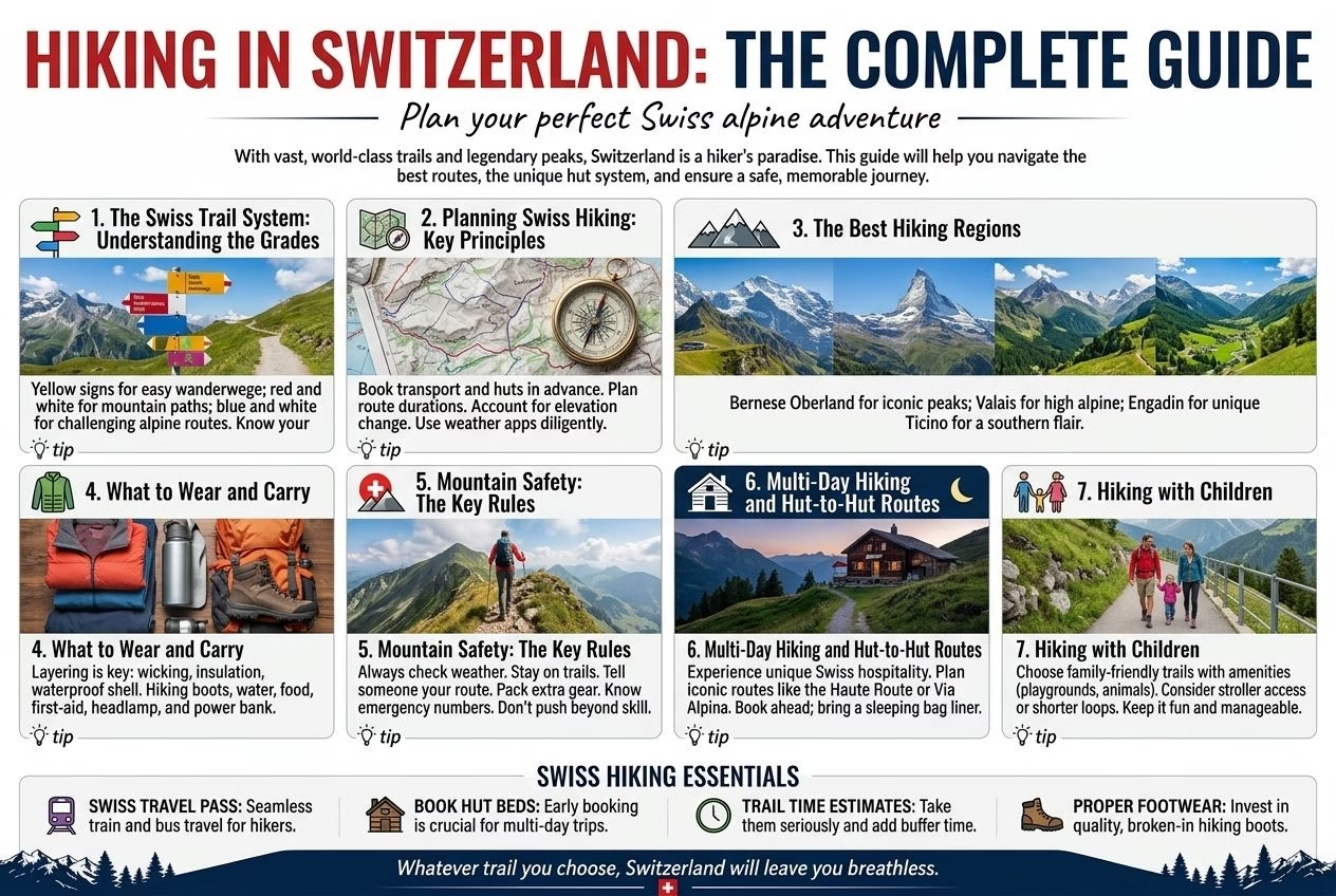
Switzerland is one of the great hiking destinations on earth. The combination of more than 65,000 kilometres of signposted and maintained trails, a mountain railway and cable car network that provides access to terrain that would otherwise require days of approach, a trail-marking system of extraordinary precision and completeness, and the Alpine scenery that has been drawing walkers since the Romantic era produces a hiking experience that has no direct equivalent anywhere in the world.
This guide covers everything needed to plan and execute Swiss hiking: the trail grading system, the best regions, the seasonal considerations, the equipment needed, and the specific safety awareness that Alpine hiking requires.
The Swiss Trail System: Understanding the Grades
Switzerland’s trails are categorised into four grades, marked with specific colour coding on posts and cairns throughout the network:
Yellow: Hiking trail (Wanderweg): The most accessible category, suitable for regular walking shoes and appropriate for visitors without hiking experience. These trails are well-maintained paths through forests, along river valleys, and over gentle hills. No special equipment required; following the yellow signs is sufficient navigation.
White-red-white: Mountain trail (Bergweg): Requires sure-footedness and some experience with Alpine terrain. These trails include steep sections, exposed paths on ridges, and sections that require using hands for balance. Appropriate footwear (hiking boots with ankle support and grip) is important. Most Jungfrau region trails above 1,800 metres fall in this category.
White-blue-white: Alpine route (Alpinweg): Requires technical Alpine experience, appropriate equipment (including potentially crampons, rope, and ice axe depending on season and conditions), and the ability to navigate in Alpine terrain without marked paths in some sections. Not appropriate for recreational hikers without Alpine training.
Yellow with blue segment: Snowshoe trail: A separate winter trail category for snowshoe routes; marked in winter only.
Planning Swiss Hiking: Key Principles
Check the current trail status: Trails above 1,800 metres may be closed due to snow from October to June; the Swiss Hiking Federation website (schweizer-wanderwege.ch) and the Bergfex app provide current trail conditions and closures. Never assume a trail is open based on summer documentation; snow conditions vary significantly by year.
Start early: Mountain weather in Switzerland deteriorates in the afternoon; afternoon thunderstorms are common in summer. Starting hikes at 7 to 8am and completing the main ascents before noon puts you in the safest weather window.
The 1,000 metre rule: A useful planning guideline: allow approximately 1 hour per 400 metres of ascent and 300 metres of descent, plus 15 to 20 minutes per kilometre of horizontal distance. A trail marked as 800 metres ascent and 4 kilometres horizontal distance takes approximately 2 to 2.5 hours one way for a fit hiker.
Water: Switzerland’s mountain streams are generally safe to drink; the high-altitude trails in the Bernese Oberland and Valais are watered by glacial streams. Carry a water bottle and refill at streams; this eliminates the need to carry large amounts of water weight on long routes. The exception: streams below livestock grazing areas may carry pathogens; use iodine tablets or a filter if unsure.
Mobile coverage: Swiss mobile networks (Swisscom, Salt, Sunrise) have surprisingly good coverage on the main hiking areas due to the infrastructure of the mountain railway system and the relay transmitters on peaks. However, do not rely on phone coverage as a safety tool; download trail maps offline (Swisstopo app, offline mapping) before setting out.
The Best Hiking Regions
The Jungfrau Region (Bernese Oberland)
The most visited and most developed hiking area in Switzerland. The combination of the Grindelwald, Wengen, and Mürren bases, the Jungfraujoch summit access, and the trail network connecting them provides hiking at every level from easy valley walks to demanding ridge routes. The specific trail infrastructure, with its combination of maintained paths, cable car access, and mountain restaurants, makes this the most forgiving region for visitors new to Alpine hiking. Full guide: Jungfrau region hikes.
Zermatt and the Valais
The area around Zermatt, beneath the Matterhorn, is the most spectacular hiking terrain in the Swiss Alps: the combination of the 4,000-metre peaks, the glacier views, and the specific quality of the Valais light produces hiking that is qualitatively different from the Bernese Oberland. More demanding, more exposed, and more rewarding at the higher levels than the Jungfrau region. Full guide: Zermatt and Matterhorn hikes.
The Bernese Oberland (beyond the Jungfrau region)
The wider Bernese Oberland, including the Haslital, the Engstlenalp, and the trail connections between the Jungfrau region and the Frutigen valley, contains some of the finest less-visited hiking in Switzerland. Full guide: Bernese Oberland hiking.
The Via Alpina
Switzerland’s trans-national long-distance hiking route, running from Vaduz in Liechtenstein to Montreux on Lake Geneva. The Swiss section covers approximately 390 kilometres in 24 stages. The Via Alpina is covered in the dedicated guide: Via Alpina route guide.
Graubünden (the Engadine)
The largest Swiss canton, with the Upper Engadine valley and its chain of high-altitude lakes (St Moritz See, Silvaplana, Sils), the Bernina massif, and the Parc Naziunal Svizzer (Swiss National Park, the only area in Switzerland where nature is completely undisturbed) providing hiking of extraordinary diversity. Less visited than the Jungfrau region; more rewarding for experienced hikers who want solitude.
The Appenzell Alps and the Alpstein
The Alpstein massif in northeast Switzerland, centred on the Säntis peak (2,502 metres), provides demanding ridge hiking with deep karst topography: the ridges are limestone and the landscape is dramatic in a completely different way from the granite and gneiss Alps of the Valais and Bernese Oberland. The Seealpsee and the Fählensee (both alpine lakes in glacial cirques within the Alpstein) are among the most beautiful small lakes in Switzerland.
What to Wear and Carry
Footwear: Hiking boots with ankle support and a grippy sole are necessary for any trail above the Yellow grade in wet conditions and for any trail in the white-red-white category. Trail shoes (lower cut, lighter) are appropriate for well-maintained Yellow trails in dry conditions. Sandals and trainers are not appropriate for Alpine hiking.
Clothing layers: Mountain weather can change rapidly. A rain jacket, a fleece mid-layer, and a base layer that wicks moisture are the minimum for any hike above 1,500 metres, even in summer.
Sun protection: UV radiation increases approximately 10 percent per 1,000 metres of altitude. Sun cream with SPF 50+, a hat, and UV-blocking sunglasses are necessary for summit excursions and long ridge walks.
Emergency items: A whistle (the international mountain distress signal is six short blasts); a foil survival blanket (weighs almost nothing, can be life-saving in an unexpected overnight bivouac); a headtorch; basic first aid. The Swiss Alpine Club rescue service (REGA) operates helicopter rescue throughout Switzerland; having the Rega app installed provides fast access to the rescue service in emergency.
Mountain Safety: The Key Rules
Never underestimate the weather. Swiss mountain weather can change from clear sunshine to thunderstorm with lightning in under 30 minutes; the specific danger of lightning on exposed ridges requires descending to shelter if storm clouds are building.
Know your exit. Before starting any hike, identify the nearest valley route and descent option in case conditions deteriorate.
Tell someone your plan. Leave your intended route and expected return time with someone before setting out; register with the mountain rescue service (or leave details with your hotel) for demanding routes.
Multi-Day Hiking and Hut-to-Hut Routes
For hikers who want more than day trips from a fixed base, Switzerland’s long-distance routes and mountain hut network open up multi-day itineraries. The Via Alpina is the major trans-Swiss long-distance route, and Swiss Alpine Club (SAC) huts along it and many other high routes provide dormitory beds and hot food without the need to carry camping equipment. For hikers who prefer sleeping outdoors, Wild Camping in Switzerland covers where that’s legally permitted and how to do it responsibly.
Hiking with Children
Switzerland’s hiking infrastructure is genuinely family-friendly: gondola and cable car access means a family can reach a high-altitude lake or ridge walk without a demanding approach hike, and many of the yellow-graded trails described above are entirely appropriate for children from around 5 years old with an adult. The Family Activities guide covers age-appropriate options in more detail, including toboggan runs and the specific mountain railways that work well with children.
Related: Jungfrau Region Hikes | Zermatt Hiking | Bernese Oberland | Mountain Safety | Packing Guide
Written by Laura Meier from Zürich, based on nearly a decade of Swiss residence and ongoing direct experience of the places, trails, trains, and bureaucratic processes described. Updated regularly as prices and conditions change; corrections and updates welcome at contact@allaboutswiss.com.