
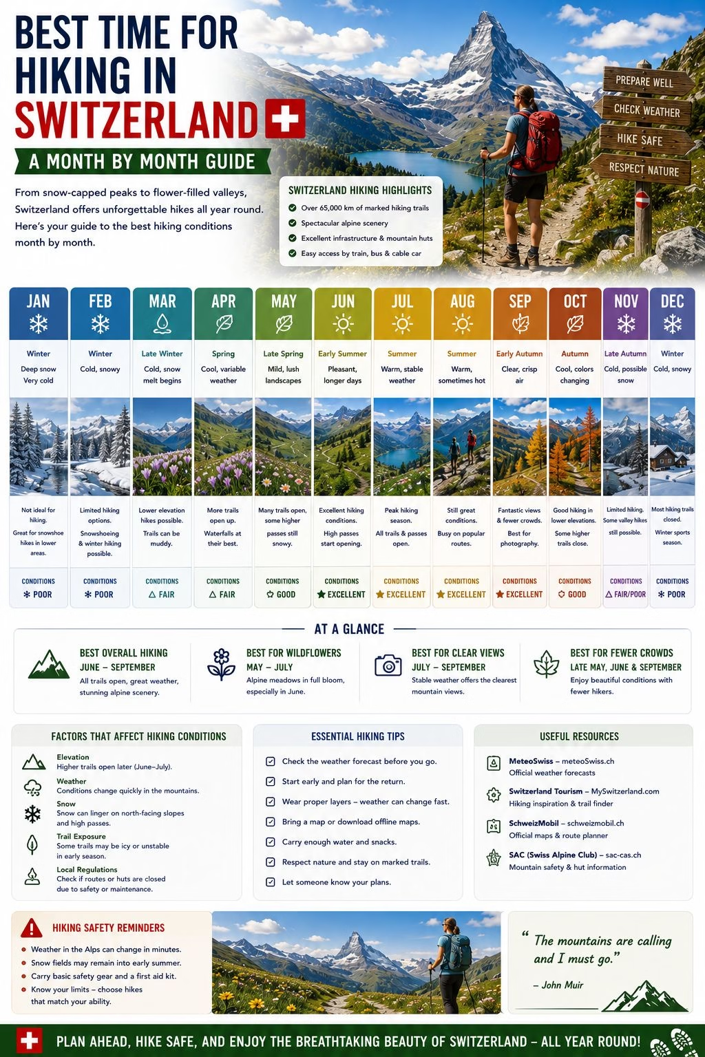
The Swiss hiking season is shorter than most first-time visitors expect. Snow can sit on trails above 1,800 metres well into June, and the first meaningful snowfall of the following winter often arrives at similar altitudes by mid-October, which leaves a genuine hiking window of roughly four months at the higher elevations that give Switzerland its reputation. Lower and valley trails have a longer season on either side of that window, so the honest answer to when to hike depends heavily on which altitude you are actually planning to walk at.
This guide pulls together the seasonal detail already scattered across the Hiking Hub and the Jungfrau Region guide into a single month by month picture, so a hiking-focused trip can be planned around the calendar rather than discovered on arrival.
The Short Answer: June to October, With September as the Sweet Spot
For most Alpine trail hiking above 1,800 metres, late June through mid-October is the realistic season, and September is consistently the best single month within it. By September, the summer school holiday crowds have thinned, trail conditions are typically dry and free of both lingering snow and the mud of early summer melt, and the light is at its best for photography. Early to mid-June and the second half of October are the shoulder edges of the season: hikeable, often rewarding, but with real variability in trail conditions that the peak months don’t have.
Month by Month
April and May: Valley and lower-elevation trails begin opening as snow melts, and wildflower season in the Bernese Oberland and Engadine meadows makes May specifically rewarding for lower-altitude walking. High routes and passes remain closed or unreliable through this period; anything above roughly 1,800 to 2,000 metres should not be assumed open without checking current conditions first.
June: A genuine transition month. Early June can still feel like spring at altitude, with many high routes only just clearing snow, while lower and mid-elevation trails are typically in good condition by mid-month. By late June, most of the classic high-Alpine routes described in the Jungfrau Region guide, including the Bachalpsee walk and the Männlichen ridge, are typically open.
July and August: The peak of the season by trail access: essentially everything is open, from valley paths to the highest maintained routes. This is also peak crowd season, coinciding with European school holidays, and afternoon thunderstorms are at their most frequent, which reinforces the general rule of starting early and completing the main ascent before midday.
September: The recommended month for most hikers with flexibility in their travel dates. Trail conditions are typically at their best (dry, clear of both snow and mud), crowds thin out significantly once school holidays end, and the light is widely considered the best of the year for Alpine photography.
October: Lower and valley trails generally remain open and are often at their most scenic with autumn colour, while higher routes begin closing progressively through the month as the first snowfalls of the season arrive at altitude. Early October can still offer excellent high-altitude hiking in a good year; late October is much less reliable.
How Altitude Changes the Calendar
The single most useful planning principle is that the calendar above shifts earlier or later depending on elevation, and treating the whole country as one hiking season is the most common mistake in trip planning. A valley walk in the Ticino or the lower Lavaux can be genuinely pleasant from April through November; the high routes around Zermatt or in the Jungfrau region have a season that can be a third as long. Anyone building an itinerary around a specific high-altitude route should treat late June to late September as the safe window, and anything outside it as needing a current conditions check rather than an assumption based on the calendar alone.
Checking Current Conditions Before You Go
Regardless of the general seasonal pattern above, trail status varies year to year with snowfall, and the only reliable way to confirm a specific route is open is to check close to the travel date rather than relying on typical seasonal timing. The SchweizMobil route pages and the websites of local tourism offices and lift operators carry current trail status, and the Mountain Weather guide covers the MeteoSwiss and Bergbericht tools for checking conditions at altitude before setting out on any given day.
Related: Hiking in Switzerland | Jungfrau Region | Mountain Weather | Best Time to Visit | Mountain Safety
Written by Laura Meier. Updated regularly as prices and conditions change; corrections and updates welcome at contact@allaboutswiss.com.